
77 Miles, One Drone: What the Longest Known BVLOS Transmission Inspection Means for Commercial Operators
A single commercial drone mission just rewrote what's possible for infrastructure inspection in North America. Here's what the operation actually involved and what it means for operators weighing BVLOS certification.
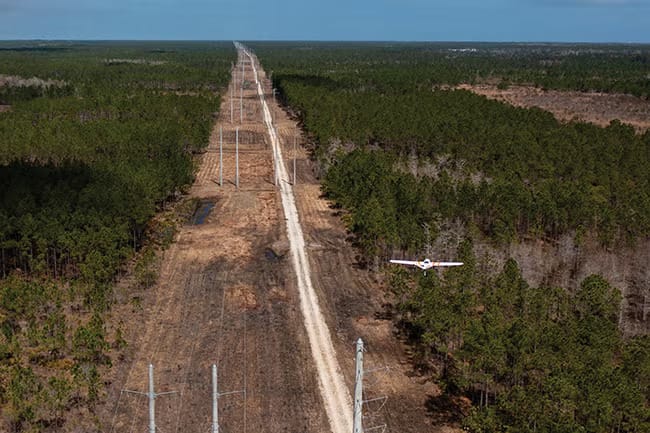
On February 3, 2026, Censys Technologies completed a commercial drone mission that would have been impossible under standard Part 107 rules, and would have required a lengthy SFOC application under Canada's previous regulatory framework.
The company flew 77.7 miles of high voltage transmission corridor between Daytona Beach and Mims, Florida, in under 2.5 hours of flight time, collecting 140 GB of LiDAR and high-resolution imagery data.
Total time on site from setup to breakdown: just over three hours.
This is what scalable BVLOS infrastructure inspection actually looks like in practice.
The Operational Detail That Matters
Most coverage of this mission has focused on the headline numbers. Let's look at what actually happened in the field:
The route cut through four distinct airspace segments, including Class C airspace around Daytona Beach International Airport and Class D airspace near Ormond Beach, plus Restricted Area A-294.
The team secured airspace authorization in approximately one month; described by the team as fast, but representative of what a well-prepared operator with proper documentation can expect under current FAA waiver processes.
The flight plan was divided into two legs: 35 miles out-and-back (Daytona Beach to Ormond Beach), then a 42.7-mile point-to-point leg to Mims. Pre-established phase lines throughout the route defined altitude transitions and control handoff points.
22 roadway crossings were classified and timed, each requiring a 1 to 3 second exposure across the corridor. A voluntary NOTAM was issued to alert manned aircraft, even though not required for the specific airspace segments used.
Battery management was tight. The aircraft landed with approximately 20% remaining, below the team's own 25% safeguard threshold, which itself allows roughly 30 minutes of remaining flight time. The planning assumption factored in a sustained 20 mph headwind for the entire route.
What This Means for Operators Considering BVLOS
The mission demonstrates that long range BVLOS inspection of linear infrastructure is operationally viable today, not theoretical, not experimental.
But it also shows what it actually requires to do it safely and legally:
- Detailed airspace analysis across multiple jurisdiction boundaries
- Precise flight planning with pre-established contingency points
- Networked operations teams capable of handing off control between stations mid-flight (demonstrated at Phase Line Blue)
- Battery reserves that make conservative assumptions about wind and conditions
For Canadian operators, the implications are direct: with Level 1 Complex BVLOS certification now available under Canada's November 2025 regulatory framework, the operational playbook Censys executed in Florida is increasingly within reach without needing an individual SFOC for every mission.
The key difference is that Canada's framework provides a certification pathway rather than requiring a case-by-case approval for each flight.
The inspection covered 77 miles of transmission corridor at roughly a quarter of the cost of comparable helicopter patrols, according to the company.
For operators working Canada's extensive transmission and pipeline infrastructure, that cost differential is the business case, and the new regulatory framework is what makes it executable at scale.

Related reading
Continue the thread.
Related posts are pulled from the same primary topic as the current article.

California Company Secures $500 Million Counter-Drone System Contract
AeroVironment received a potential $500 million Army contract for commercial counter-UAS and counter small-UAS capabilities, reinforcing demand for drone defense systems.

New Pentagon Unmanned Czar Will Oversee Most Drone Programs
The Pentagon has created a Direct Reporting Portfolio Manager for Unmanned Systems, a move that centralizes oversight of many military drone and uncrewed programs.
San Antonio Drone Delivery Is Live, But The Early Signal Is Constraint, Not Scale
Amazon's Prime Air service is operating in San Antonio, but local reporting points to a narrow service area and real availability constraints. For operators, that is the useful lesson.